|
|
|
|
STREAM MAPPING
| |
| |
Stream mapping is done for various reasons, but the objective is to document stream features such as erosion, soil and vegetation type, creekbed gradient and width, storm drain outfalls, bridges, habitat sites.
| |
|

| Mapping Survey
---- main stream
City of North Vancouver
1998
Voluntary
BC Urban Salmon Habitat Program (USHP) project grant
Mapping was conducted by a CNV staff person. Features were photographed and recorded.
Mosquito Creek, Wagg Creek, Lower Mission Creek
| |
| |
| Mapping Survey
---- main stream
North Shore Streamkeepers & Mosquito Creek Stewardship Society
1997
Voluntary
Mapping was conducted by volunteers. Features were photographed, measured and recorded.
Mosquito Creek from Bewicke Bridge to Highway 1. Thain Creek from confluence to Westview culvert.
Mosquito Creek, Thain Creek
| |
|
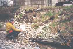
Mapping erosion points on Mosquito Creek
| |
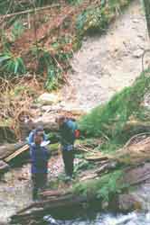
Mapping erosion on Thain Creek
|
|
| |
| Mapping Survey
---- main stream
District of North Vancouver
1997
Voluntary
Mapping was conducted by trained staff. Features were measured using GPS and recorded. Data was entered unto the District's GIS mapping system and can be accessed by request.
Mosquito Creek, Thain Creek, Upper Mission Creek
| |
|
|
|